Back Hambleton District CEB Ardal Hambleton Welsh Hambleton German Hambleton Spanish همبلتون Persian Hambleton (district) French Համբլտոն Armenian Hambleton Italian 햄블턴 Korean Hambleton (district) Dutch
54°20′02″N 1°25′44″W / 54.334°N 1.429°W
Hambleton District | |
|---|---|
District | |
 Council Offices, Northallerton | |
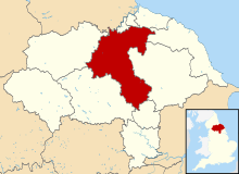
 Shown within North Yorkshire | |
| Sovereign state | United Kingdom |
| Constituent country | England |
| Region | Yorkshire and the Humber |
| Administrative county | North Yorkshire |
| Admin. HQ | Northallerton |
| Government | |
| • Type | Hambleton District Council |
| • Leadership: | Leader & Cabinet |
| • Executive: | |
| • MPs: | Rishi Sunak, Kevin Hollinrake |
| Area | |
| • Total | 506.27 sq mi (1,311.23 km2) |
| Population (2021) | |
| • Total | 91,037 |
| • Density | 180/sq mi (69/km2) |
| Time zone | UTC+0 (Greenwich Mean Time) |
| • Summer (DST) | UTC+1 (British Summer Time) |
| ONS code | 36UC (ONS) E07000164 (GSS) |
| Ethnicity | 99.2% White |
| Website | www |
Hambleton was a local government district in North Yorkshire, England. The administrative centre was Northallerton, and the district included the outlying towns and villages of Bedale, Thirsk, Great Ayton, Stokesley, and Easingwold.
The district was formed by the Local Government Act 1972 on 1 April 1974, as a merger of Northallerton Urban District, Bedale Rural District, Easingwold Rural District, Northallerton Rural District, and parts of Thirsk Rural District, Stokesley Rural District and Croft Rural District, all in the North Riding of Yorkshire. It was subsumed into the new unitary authority of North Yorkshire Council on 1 April 2023.
© MMXXIII Rich X Search. We shall prevail. All rights reserved. Rich X Search
